Malagasy Minerals confirms graphite field at Maniry

THE DRILL SERGEANT: Malagasy Minerals (ASX: MGY) has claimed to have confirmed the company’s Maniry project in Southern Madagascar is host to a major graphite field.

The company said recent systematic traverse surface sampling has identified at least 12 major lenses of high-grade graphite mineralisation with widths ranging from 75 metres to 250 metres and average grades from 5 per cent graphitic carbon to 12.13 per cent graphitic carbon.

Traverse rock chip results include:

Lens B:
150 metres at 8.28 per cent carbon;

Lens D:
175m at 11.75 per cent carbon;

Lens E:
250m at 8.67 per cent carbon;

Lens J:
90m at 12.13 per cent carbon;

Lens K:
100m at 9.80 per cent carbon;

Lens L:
150m at 10.18 per cent carbon; and

Lens M:
175m at 7.26 per cent carbon.

The Maniry project is located in the southern part of Malagasy’s Ampanihy project, which it has identified as being prospective for not only high-grade, high-quality graphite deposits but also for large-scale intrusive related nickel-copper-PGM deposits and molybdenum-selenium-REE deposits.


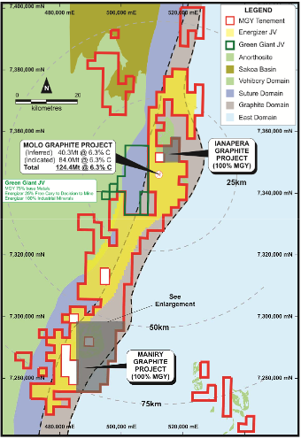
Project location plan. Source: Company announcement


Graphite exploration completed by Malagasy earlier this year at Maniry identified a series of large, high-grade outcrops of graphite mineralisation within a broader graphite trend covering an area of approximately 8 kilometres by 4 kilometres.

To determine the continuity of grade across the width of these graphite lenses a series of the outcrops were selected for more detailed sampling.

“This program of work has delineated substantial widths of graphite mineralisation at remarkably consistent grades and clearly demonstrates that potential exists at the Maniry project for a significant graphite deposit(s) to be defined,” Malagasy Minerals said in its ASX announcement.

Malgasy considers it has confirmed the potential of the Maniry project and will now enter the next phase of assessment, which will involve:

Mineralogical evaluation to determine flake size and high level quality characteristics;

Determination of potential upgrade purity levels; and

If the above work justifies, a program of additional traverse sampling and trench-costean sampling will be undertaken when the 2014 field season commences.

Website:
www.malagasyminerals.com


Impact Minerals identifies new Mulga Tank anomaly

THE DRILL SERGEANT: The maiden drill program of Impact Minerals (ASX: IPT) at the company’s Mulga Tank project, located 200 kilometres northeast of Kalgoorlie in Western Australia has caused a bit of excitement.

The drilling is testing a number of EM anomalies within E39/988, and has already identified widespread copper mineralisation around the Mulga Tank Dunite in drill holes at Conductor 1 and Conductor 2.

This has prompted Impact Minerals to review the ionic leach soil geochemistry data over the area.

A large and strongly elevated copper-in-soil anomaly defined by assays above 3000ppb and up to 4,750ppb that covers approximately 8 square kilometres has been identified over the south east quadrant of the Mulga Tank Dunite and also its southern contact with the surrounding rocks.


Image of the Total Magnetic Intensity from airborne magnetic data
over the Mulga Tank Dunite (white outline). Source: Company announcement


The anomaly along the southern contact mostly overlies three steeply dipping EM conductors identified by the ground survey and which lie within the dunite.

Impact had previously considered these conductors to be of a lower priority but these have now been upgraded.

The company indicated the elevated copper anomaly to also be coincident with gold and silver-in-soil anomalies.

This area is also partly coincident with anomalous nickel-and palladium-in soil responses associated with Conductor 4.

“This is very encouraging and accordingly the entire southeast part of the Mulga Tank Dunite and immediate surrounding area is now the immediate priority area of interest for Impact,” the company said in its ASX announcement.

“The ionic leach technique is a weak chemical digest designed to detect subtle geochemical responses that may have leaked through transported cover to the surface.

“The discovery of nickel sulphides at depth beneath a nickel-in-soil anomaly at Conductor 1 gives confidence that the technique is working in places over the Mulga Tank Dunite and that the copper-gold-silver responses may indicate a bedrock source.”

Impact is still drilling at Conductor 3 to the immediate northwest of the Mulga Tank Dunite at present and expects to reach its target depth by the end of the week.

The company will then move the rig back to Conductor 1 to test the two conductors identified by the down-hole EM Survey before moving to Conductor 4.

Email:
info@impactminerals.com.au

Website:
www.impactminerals.com.au

White Rock upgrades eponymous deposit Resource

THE DRILL SERGEANT: White Rock Minerals (ASX: WRM) has completed modelling and Resource estimation to upgrade the White Rock silver deposit Resource.

White Rock silver deposit is one of eight deposits making up the company’s Mt Carrington project.

The majority of the four largest gold-silver deposits at the Mt Carrington project are now classified as Indicated Resources.

“The upgrade to Indicated Resource for a large quantity of the White Rock silver deposit now completes the major geological component in the path to development of the Mt Carrington gold-silver project,” White Rock Minerals managing director Geoffrey Lowe said in the company’s announcement to the Australian Securities Exchange.

“Based on the pit optimisation work from the scoping study completed in 2012 the proportion of Indicated Resource included in the scoping study approximates 100 per cent for Lady Hampden, 75 per cent for Strauss, 60 per cent for Kylo and 60 per cent for White Rock.

“On that basis we are happy that the geological confidence in each deposit will allow us to proceed with feasibility studies in 2014.”


White Rock prospect: Location of Indicated and Inferred Resource,
current drilling density and historical mine workings. Source: Company
announcement


White Rock explained the upgraded global Resource has slightly more tonnes at an overall slightly lower grade than the previous estimate coming in at:

4.4 million tonnes at 58 grams per tonne silver for 8.192 million ounces of silver (previously 4.1 million tonnes at 62g/t silver for 8.194 million ounces of silver).

The new Indicated Resource stands at:

1.7 million tonnes at 77g/t silver for 4.214 million ounces of silver.

White Rock said this presents a much higher grade compared to the overall resource, and represents over 50 per cent of the original Inferred Resource.

The company also pointed out that the drilling it completed to upgrade the Resource has resulted in a much more robust interpretation of the geology, alteration and mineralisation of the White Rock deposit.

White Rock expects the core samples will provide sufficient material to finalise a metallurgical testwork optimisation process during the feasibility study, as well as enable a precious metal concentrate to be generated for marketing purposes, which it considers to be an important part of the final feasibility assessment.

Email:
info@whiterockminerals.com.au

Website:
www.whiterockminerals.com.au

Tawana Resources intersects high-grade itabrite mineralisation

THE DRILL SERGEANT: Tawana Resources (ASX: TAW) has been encouraged by initial results from an ongoing resource evaluation drill program currently underway at the company’s 100 per cent-owned Mofe Creek iron ore project in Liberia, West Africa.

Tawana has received assay results received for the first batch samples from the RC resource drilling completed at the Gofolo Main prospect.

Highlights of drilling intersections reported include:
 
18 metres at 48.8 per cent iron from 2 metres;

46m at 40.4 per cent iron from surface; and

50m at 31 per cent iron from surface.


Significant intersections at Gofolo Main over Digital Terrain Model image. Source: Company announcement


“Initial assay results from the Gofolo Main prospect continue to confirm high-grade mineralisation potential with significant widths and grade intersected along strike from previous reconnaissance drilling,” Tawana Resources managing director Len Kolff said in the company’s announcement to the Australian Securities Exchange.

“The successful drilling campaign at Gofolo Main greatly extends the potential mineable resource footprint at this prospect, and with similar mineralisation observed to previous holes, the effective production of a plus-60 per cent iron product via simple crushing and gravity separation should be confirmed in the upcoming metallurgical testwork program.”

Tawana said the drilling at the Gofolo Main prospect has confirmed intersections of high-grade, coarse itabirite mineralisation from surface.

It has also extended the Gofolo Main strike continuity by an additional 125 per cent from 0.8 kilometres to 1.8km, whilst mineralisation width has increased by an additional 50 metres in the central portion of the prospect.

Email:
admin@tawana.com.au


Website:
www.tawana.com.au

Carpentaria Exploration confirms second gold zone at Advene

THE DRILL SERGEANT: Carpentaria Exploration (ASX:CAP) has been encouraged by gold results it has received from rock chip and soil samples taken at the company’s 100 per cent-owned Advene gold project in New South Wales.

The Advene project is located in the central Lachlan Fold Belt, just 80 kilometres from the Cowal gold mine and 320km north-west of Canberra.

The company said a number of samples contained visible gold while results returned numbers of up to 204 grams per tonne gold in rocks and 0.63g/t gold in soil samples.

Carpentaria explained it had carried out the latest round of sampling to follow-up previous initial reconnaissance field work results, which had highlighted the potential for intrusion-related gold system-style (IRGS-style) deposits in a largely unexplored area of the belt.

The results were obtained during a systematic follow-up surveying of a mineralised zone Carpentaria had identified in October this year.

This second lode zone, named Josephine Moulder East (JME), is a parallel structure located 200m to the east of the known Josephine Moulder (JM) prospect.


Summary plan of the Josephine Moulder prospect area. Source: Company announcement


The JME zone remains untested by drilling.

Highlight results included four grab rock samples of quartz-sulfide vein spoil with occasional visible gold taken from a historical prospecting pit, JME-P5, located along the JME lode zone.

The weighted average grade for all four rock samples from JME-P5 (8 kg) was 94g/t gold and 109g/t silver.

As well as the results from JME-P5, Carpentaria also received good results 150m along strike to the south from an in-situ, approximately 20cm wide, milky quartz vein from the JME-P2 historical prospecting pit.

Highlight results include:

At JME–P5

204 g/t gold, 273 g/t silver;

104g/t gold, 100g/t silver;

71g/t gold, 56g/t silver; and

20g/t gold, 51g/t silver.

At JME–P2

32g/t gold, 172g/t silver.

“It is highly-encouraging and exciting to find such high grades in different locations at the surface and visible gold,” Carpentaria Exploration managing director Quentin Hill said in the company’s announcement to the Australian Securities Exchange.

“This discovery builds on the earlier results that extended the known mineralisation from the JM area.

“In JM and JME, we have now identified two parallel mineralised structures with very significant surface gold and silver results, each over 350 metres long and potentially 10 metres or greater wide, open to the south and with a known extension 1,000 metres to the north.

“Importantly for future economic considerations, the parallel zones are located approximately 200 metres apart and with potential for lower grade halos around these structures to be present.”

Email:
info@capex.net.au
 

Website:
www.capex.net.au

Gold Road Resources doubles Gruyere discovery

THE DRILL SERGEANT: Gold Road Resources (ASX: GOR) has completed a 20 hole infill and extensional RC drilling program, which it claims has doubles the strike length of the Gruyere Prospect at the Dorothy Hills Trend.

The Gruyere prospect is located at the Dorothy Hills project area, 25 kilometres east of the high-grade Central Bore deposit, within the company’s 100 per cent-owned North Yamarna tenements in Western Australia.


Gruyere prospect, Dorothy Hills project area with significant intersections highlighted. Source: Company announcement

Gold announced results of RC drilling and one metre re‐sample assays in October and earlier this month, which had identified its gold discovery at the Gruyere prospect.

Mineralisation was initially identified over a 400 metre strike in two sections of RC holes drilled approximately 40 metres apart on section.

Gold Road said the results from the recently completed drilling program has extended this mineralisation 200 metres to the north and to the south for a new total strike length of 800 metres with intersections reported at depths of up to 140 metres below surface.

Best gold intercepts from one ‐metre sampling (at 0.5 grams per tonne gold cut‐off, minimum two metre intersection) included:

75 metres at 1.39g/t Au from 20 metres, including 2 metres at 11.76g/t Au from 26 metres, and 18 metres at 1.51g/t Au from 36 metres; (13GYRC0034)

42m at 1.56g/t gold from 2m, including 14m at 2.21g/t gold from 5m, 6m at 1.71g/t gold from 22m, and 74m at 3.43g/t gold from 31metres and 14m at 1.57g/t gold from 52metres, including 11m at 1.78g/t gold from 55m; (13GYRC0027)

74m at 1.15g/t gold from 46m to end of hole, including 6m at 1.68g/t gold from 56m, 10m at 1.32g/t gold from 66m, and 22m at 1.35g/t gold from 89m; (13GYRC0035)

Highest individual one ‐metre assays returned:

1m at 21.65g/t gold from 26m and 1m at 5.88g/t gold from 39m; (13GYRC0034)

1m at 10.48g/t gold from 22m; (13GYRC0037) and

1m at 7.54g/t gold from 50m. (13GYRC0025)

“We are extremely encouraged with this discovery at Gruyere and the rapid growth in size that we have experienced in such a short space of time,” Gold Road Resources executive chairman Ian Murray said in the company’s announcement to the Australian Securities Exchange.

“The most northern drill line has delivered the greatest horizontal width (180 metres), together with consistent gold mineralisation from a shallow depth of 10 metres below surface to a maximum vertical depth drilled of 105 metres.

“Given its horizontal width, its consistent mineralisation and the shallow depth we are encouraged that this could develop into a potential bulk mining opportunity.”

Gold Road said it has a further program of RC drilling planned to provide a consistent grid measuring 100m along strike by 40 to 80m across strike over the full 1,200m interpreted potential strike of the Gruyere prospect, which is expected to enable it to complete a detailed geological assessment.

The company explained that previous analysis of existing geophysical data (aeromagnetic) and sparse geochemical data has suggested potential for a repeat unit of the intrusive to continue to the north and east providing a potential parallel zone.

A reconnaissance aircore drilling program has been proposed to test for the extent of the intrusive footprint to the north and east of the current Gruyere prospect area.

Gold Road believes any positive identification of further anomalously mineralisation could open up further exploration potential of the Yamarna Belt.

Email:
perth@goldroad.com.au

Website:
www.goldroad.com.au

Rox Resources identifies new Fisher East nickel prospects

THE DRILL SERGEANT: Rox Resources (ASX: RXL) has identified a number of new nickel sulphide targets at the company’s Fisher East nickel sulphide project, located 500 kilometres north of Kalgoorlie in Western Australia.

The new targets were identified during a recent drilling program of 191 aircore holes.


Fisher East ultramafic belt – prospect locations over interpreted geology. Source: Company announcement


“The number of high-quality targets identified by this drilling augurs well for the chances of further nickel sulphide discoveries,” Rox Resources managing director Ian Mulholland said in the company’s announcement to the Australian Securities Exchange.

“Some of the targets show similar or even higher values compared to our initial RAB drilling results that resulted in the Camelwood discovery, particularly Cannonball, where the new discovery of massive nickel sulphides is very exciting.

“The anomalies also show elevated levels of copper, platinum, palladium and gold, which indicate a magmatic source for the nickel.”

The target that has grabbed Rox’s attention is the Cannonball, located around 500 metres south of the Camelwood deposit.

The Cannonball prospect has been defined by six lines of aircore drilling, two of which FEAC149 and FEAC160intersected massive nickel sulphides.

Drill result highlights from Cannonball include:

Hole FEAC149
11 metres at 1.27 per cent nickel, 1723ppm copper, 773ppb platinum-palladium-gold (PGE) from 56m, including 3m at 3.42 per cent nickel, 1585ppm copper, 1077ppb PGE from 62m, including 1m at 5.83 per cent nickel from 62m;

Hole FEAC160
14m at 0.77 per cent nickel, 641ppm copper, 605ppb PGE from 77m in, including 5m at 1.35 per cent nickel, 1121ppm copper, 1214ppb PGE from 81m;

Hole FEAC159
12m at 0.37 per cent nickel, 214ppm copper, 71ppb PGE from 56m; and

Hole FEAC152
3m at 0.38 per cent nickel, 327ppm copper, 169ppb PGE from 80m.

Rox said the high levels of nickel, copper and PGE present at Cannonball make it an immediate high-priority drill target.

Other targets include three within the Emu Bush prospect trend is located about 2.5km to the west of Camelwood.

Drilling at Emu Bush North returned:
Hole FEAC032
8m at 0.46 per cent nickel, 8ppm copper, 5ppb PGE from 12m;

Hole FEAC114
10m at 0.23 per cent nickel, 15ppm copper, 18ppb PGE from 20m; and

Hole FEAC115
6m at 0.27 per cent nickel, 16ppm copper, 15ppb PGE from 23m.

This area also recorded the highest gold value of 1.74g/t gold from 43m depth in hole FEAC114.

Emu Bush Central, a prospect with coincident geochemical and VTEM anomalies, returned:

Hole FEAC051
2m at 0.14 per cent nickel, 195ppm copper, 47ppb PGE from 30m.

Hole FEAC004 also recorded 3m at 0.06 per cent nickel, 0.16 per cent copper, 0.25 per cent zinc from 65m depth, with zinc and copper relict sulphides evident.

Drilling at Emu Bush South returned:

Hole FEAC091
5m at 0.19 per cent nickel, 102ppm copper, 38ppb PGE from 20m.

The Twinleaf prospect trend lies about 1.5km north-west of the Camelwood nickel sulphide deposit.

It has been defined by eight lines of aircore drilling over a 3km strike length with drill result highlights of:

Hole FEAC037
12m at 0.3 per cent nickel, 24ppm copper, 19ppb PGE from 25m;

Hole FEAC056
20m at 0.27 per cent nickel, 67ppm copper, 21ppb PGE from 10m;

Hole FEAC082
4m at 0.48 per cent nickel, 57ppm copper from 29m;

Hole FEAC128
14m at 0.49 per cent nickel, 33ppm copper, 15ppb PGE from 11m; and

Hole FEAC129
10m at 0.44 per cent nickel, 46ppm copper, 26ppb PGE from 22m.

The Red Mulga prospect trend is located about 4.5km south of the Corktree prospect, and Rox considers it to be an extension of the Camelwood ultramafic unit (or equivalent).

It is defined by two lines of aircore drilling over about a 1km strike length, with results including:

Hole FEAC183
5m at 0.13 per cent nickel, 44ppm copper, 25ppb PGE from 15m; and

Hole FEAC184
5m at 0.22 per cent nickel, 98ppm copper, 33ppb PGE from 15m.

Rox indicated it would select a list of high-priority targets from the latest drilling as soon as possible, with the timing depending on the availability of drilling rigs.


Email:
admin@roxresources.com.au

Website:

www.roxresources.com.au


Robust Resources hits possible extension to Romang Resource

THE DRILL SERGEANT: Robust Resources (ASX: ROL) has followed up a recent resource estimate with news subsequent drilling has demonstrated the potential to increase it.

Robust released the following resource estimate last week for the Manganese Valley and Batu Hitam West prospects on the company’s Romang Island project.


Manganese mineral resource estimate. Source: Company announcement

The company has since received assay results from the drilling of diamond drill hole LWD 372 located at Batu Hitam South, approximately 130metres to the south of the current Manganese Valley mineral resource.

LWD 372 intersected near-surface, high-grade manganese mineralisation, which Robust considers to indicate extensions to the current manganese resources are highly likely.

Assays returned:
6.2 metres at 45 per cent manganese from 10.8m, including 2.5m at 54 per cent manganese from 13.3m.

LWD 372 also encountered polymetallic mineralisation deeper in the hole, which was still registering base metal mineralisation grading 7.59 per cent combined base metals when the hole was terminated early for technical reasons.

“Following the release of our maiden manganese mineral resource estimate, we are pleased to report more near-surface, high-grade manganese assay results,” Robust Resources managing director Gary Lewis said in the company’s announcement to the Australian Securities Exchange.

“These results show that an increase to the manganese JORC resource is very likely.

“Drilling is ongoing south of Manganese Valley as this target area is highly-prospective for manganese, in addition to precious and base metals.

“The conceptual development path for Romang is now taking shape.”

Robust is currently conducting a scoping study on the manganese, which is anticipated to be completed in December, 2013.

An updated JORC (2012) compliant mineral resource is due to be completed by February 2014 and on the regulatory side, while progress is being made towards transitioning from exploration licence to mining licence.

“The manganese project is seen as a low CAPEX, low-risk project that could be developed in a short timeframe and have an immediate and positive return on investment,” Lewis continued.

“Infrastructure established for the manganese project could be utilised during construction and operation of the subsequent polymetallic project.”

Email:
info@robustresources.com.au

Website:
www.robustresources.com.au

Dacian Gold encounters more Jupiter gold

THE DRILL SERGEANT: Dacian Gold (ASX: DCN) has continued its run with the drill bit at the Jupiter prospect, located on the company’s 100 per cent-owned Mt Morgans gold project in the Laverton District of Western Australia’s North Eastern Goldfields.

The latest drilling conducted by the company at Jupiter has intersected a further high-grade result, which Dacian said has extended a recently discovered high-grade lode position.

Hole 13JUDD018 intersected:

17.2 metres at 4.8 grams per tonne gold from 160 metres (mainlode), including 3.3m at 17.1g/t gold from 169.7m and 3.7m at 5.8g/t gold from 147m (hangingwall lode).


Section with drill holes 13JUDD018 & 13JURD007 and interpreted
moderately dipping, high grade lode. Source: Company announcement


The mineralisation is located approximately 50m west of a recently reported high-grade result returned in 13JURD007 and has been interpreted by Dacian to correlate with the lode structure intersected in three previously reported Dacian holes which include:

13JUDD007:
6.9m at 8.3g/t gold from 154.1m within 26m at 3g/t gold;

13JURD006:
6.1m at 4.8g/t gold from 166.9m within 16.8m at 2.1g/t gold; and

13JURD002:
1.25m at 6.1g/t gold from 122.7m within 3.2m at 2.62g/t gold.

Dacian explained that all high-grade intersections it has encountered to date lie within a single moderately north-east dipping lode structure that cuts both the syenite intrusive and the adjacent host basalt.

The latest mineralisation intersection is located 1000m south of the existing 73,000 ounce Mineral Resource and the Jupiter pit where similar style lode structures were mined in the 1990s.

“All four holes drilled into this lode position have encountered high-grade gold and the structure remains open in all directions,” Dacian Gold managing director Paul Payne said in the company’s announcement to the Australian Securities Exchange.

“We are encouraged that the new mineralisation bears similarities with the Jupiter mine, located one kilometre north; as well as that seen in the world-class Wallaby mine located seven kilometres to the south-east.

“We are focused on defining the dimensions of this new lode and are continuing to explore for further high-grade gold mineralisation at the prospect.”

Email:
info@daciangold.com.au

Website:
www.daciangold.com.au

White Rock Minerals encouraged by more Red Rock gold

THE DRILL SERGEANT: White Rock Minerals (ASX: WRM) has received further encouragement from recent drilling undertaken at the Red Rock prospect, located at the company’s 100 per cent-owned Mt Carrington project in New South Wales.

According to White Rock the recent drilling has demonstrated potential to expand the company’s 700,000 ounce gold equivalent Resource base at Mt Carrington.
 
White Rock completed a six-hole drilling program at Red Rock in October, designed to investigate the interpreted southern extension to the 54,000 ounces of gold Resource defined at the Deadman’s Zone in July 2013.

It was also tasked with an initial test of geochemical targets along strike of the historical mine workings at the Main Shaft and Cliff Workings.

The first two holes in this program have returned promising assay results and have defined a broad zone of gold mineralisation from surface, immediately to the south of and consistent with the Deadman’s Resource.

Results include:

RRDD024:
40.8 metres at 0.5 grams per tonne gold from 1.8m, including 1.2m at 2.6g/t gold from 1.8m; and

RRDD025:

45.5m at 0.7g/t gold and 23g/t silver from surface, including 10m at 1.2g/t gold from surface and 6m at 0.8g/t gold and 105g/t silver from 22m.


Cross Section displaying results for drillhole RRDD024 and 025, along with previous drillholes. Source: Company announcement


“The drilling results are very pleasing and continue to demonstrate the district’s emerging potential to provide new gold-silver deposits to add to our existing Mt Carrington inventory,” White Rock Minerals managing director Geoffrey Lowe said in the company’s announcement to the Australian Securities Exchange.

“It also demonstrates our ability to add potential ounces at low spend rates which is important for our development plans under consideration.

“The 50 metre extension to the mineralised zone at Deadman’s is significant given the current 300 metre by 100 metre footprint of the Inferred Resource, which remains open along strike and at depth.

“The strong silver grades reported in RRDD025 are also a bonus and will potentially add value to an updated Mineral Resource for Red Rock in the future.”

White Rock said it is waiting on results for the remaining four holes, which it anticipates reporting to the market in due course.

Email:
info@whiterockminerals.com.au

Website:
www.whiterockminerals.com.au